![WPSL Republic [Official Web Site] - Beta](https://wpslol.org/images/wpsl_3dr_circle_500.webp)

WEBSITE LOADING...
Segui WPSL Republic in Live Streaming su Twitch (anche su Youtube in Simultanea) tra le 22:30 e 01:30 dove l'admin farà dirette di Hangout (Just Chatting) e Gaming. | |
 | |
- Details
- Also available:
")
- Hits: 341
Al-Xeon (الزيون) in phonetic Arabic Al-Ziun or Al-Zuyun (in phonetic Arabic) is the Northern Metropolis of the country located in the northernmost part of the country overlooking the Mediterranean Sea divided into 27 districts and 5 municipal areas. The old city of Al-Xeon dates back to 1530 (and is historically the first city to be founded in the country) and comprises the districts of Haql and part of the districts of Al-Xeon HQ, 'Ahmal Misbah and Al'Azraq (also included the city of Al-Taka which was separated from the city of Al-Xeon has because of the population too conservative where in 2015 the WPS LOL issued an administrative decree to separate the area of Al-Taka since that time the popular uprisings are sank until it disappeared), it was the previous capital of the country and it was between 1530 and 1991; the rest of the districts were built recently in the last 20-30 years; most of the population lives in the administrative district (Al-Xeon HQ), between 2005 and 2015 the administrative area was overpopulated as the rest of the city (i.e. 80% was completely destroyed by the war between 1990 and 2005 , after the reconstruction of the destroyed districts and neighborhoods, the population has been evacuated where attempts are still being made to move the young population into the districts of the new city (mainly the western part of the city). Al-Xeon between 1920 and 2005 was the stronghold of the British (and even before that of the Ottomans), the civil war that broke out in the 1990s completely almost leveled the city with the exception of the administrative area and the western area ( still empty which would later become the new city), after 2005 the population migrated to other cities (especially to the new capital founded in 1991), where many companies, infrastructures were dismantled and transferred to WPS LOL City, like all the governmental and institutional areas where they were completely looted by the rebels and transferred to the current administrative capital; in the post-conflict period the city of Al-Xeon had to face a long ten-year period of degradation, popular uprisings, poverty and many various public order problems at least until the years of the second economic boom where various investors started reconstruction after 2014 and only recently the city after years of difficulty is timidly starting to return to normal with a situation that is slowly stabilising. The official languages of this city are Arabic and English (Italian is not widespread but there is also some Turkish minority due to the Ottoman domination); there are some neighborhoods where English is more widely spoken than Arabic. Most of the inhabitants of Al-Xeon are Muslims for 68% (35% of these are not practicing) then there is a 24% of unaffiliated (atheists and agnostics) the remaining 8% are Christian minorities, Jews and other religions; Islam was in the past very conservative even in this city where minorities were tolerated (although not always and during the Ottoman domination there were occasions of forced conversion), after the British invasion there was a renewal of Islam on a more secular basis , only after the black-fuchsia revolution were the state separated from religion, the city had a conservative status until at least 2015 after which the city began the phase of secularization. The population is 1.61 million inhabitants. (sixth largest city by population in the country). The city of Al-Xeon has been administered since 1555 (the first city in the country to be created administratively and was the capital of the country until 1990), the city between 1555 and 1921 had no mayors but chiefs who were sovereigns, kings, princes, imams, clerics or any candidate, but during the Ottoman Empire they were decided by the governor of the country's former capital (Al-Xeon) until 1921, after which, during the English administration, the choice of mayor was decided by the King under council of the British colony) where the city was established; after 2005 with the consequent fall of the English colony by the Italo-Arab rebels who breached the besieged city and then completely destroyed by bombing (the city lost its administrative capital status in 1990 which passed to WPS LOL City), the city later abolished the monarchical power and the mayor will be elected by the people in democratic elections. the English administration the choice of the mayor was decided by the King under the advice of the Government of the British colony); after 1970 with the establishment of the city the absolute monarchy system was abolished for a constitutional system with mayors elected by the government council, after the fall of the English colony the elective power of the mayor is decided by the people under democratic elections. Between 1555 and 1922 in Al-Xeon ruled the "Zuyun Al'Azraq" Dynasty, after which with the British colonization which replaced the Ottoman Empire the administration of the country as well as the area of Al-Xeon was assigned to the King Faysal Zuyun Al'Azraq with an Islamic Democracy party which had influence in almost all the country except Al-Plasma area, the King ruled between 1922 till 1991 where between 1980 and 2000 riots started popular throughout the country promoted by the Italo-Arab rebels who drove out the British who had to hole up in Al-Xeon in a siege which ended in 2005 with the defeat of the British colonial empire by the rebels who then created the WPS LOL, the King was killed and many British servicemen were executed; in 2007 during the first democratic elections he won the mayor of the Conservative Green Party with 88% of the votes (the city of Al-Xeon was under conservative administration for at least 9 years, then a new more progressive generation emerged and the mayor despite 3 consecutive terms began to lose support because the city of Al-Xeon, even if freed from the colonial oppressors and all the various post-war criminals, has so many social problems, so much so that the mayor Samìr Al-Xeon governed from 2007 to 2016 who was a Muslim moderate but not fully secular; in 2016 the conservatives lose power in Al-Xeon where the black-fuchsia progressive seculars allied with the locals of Al-Xeon to make a mixed coalition that wins with 52% overtaking the remaining conservatives at 46 %; finally, from 2019 a girl (another friend of the admin of a non-practicing and secular Muslim family) has been running as a candidate: "Faya Farasha Ziun" who is running with Onda Nero-Fuchsia winning with a clear 58% and for the first time in 12 years of the foundation of the republic, the WPS LOL also snatches the city of Al-Xeon from the conservatives and takes all the capitals of the country decreeing the political defeat of the conservatives who are supported only in the suburbs (but are losing support there too). 1555-1922 (Zuyun Al'Azraq Dynasty) Al-Xeon Al-Xeon Skyline (2021). Al-Xeon QG Al Yaqut You steal Zamarad Nawal Xeon-Rasha-Nour (Former Al'Azraq) Fustat-Kamala-Maskanah-Dahab-Sumandar-Thuraya-Ayn Hafer (Formerly Misahat) Zahara-Sakeena-Reem (Ex 'Ahmal Misbah) Muhammad-Sheen-Shatha (Former Zajaz) Yatir West-Yatir East (Formerly Yatir) Haql About
Al-Xeon Policy
1922-1991 (King Faysal Zuyun Al'Azraq) Islamic Democratic Party
1991-2005 (Abdul Zuyun Al'Azraq) Moderate Islamic Party
2007-2010 (Samìr Al-Xeon) Green Conservative Party 88%
2010-2013 (Samìr Al-Xeon) Green Conservative Party 64%
2013-2016 (Samìr Al-Xeon) Green Conservative Party 55%
2016-2019 (Sefir Daniel Ramses Al'Azraq) Al-Xeon Local List + Fuchsia Black Wave 52%
2019-2024 (Faya Farasha Ziun) Wave Black-Fuchsia 58%
Al-Xeon Districts
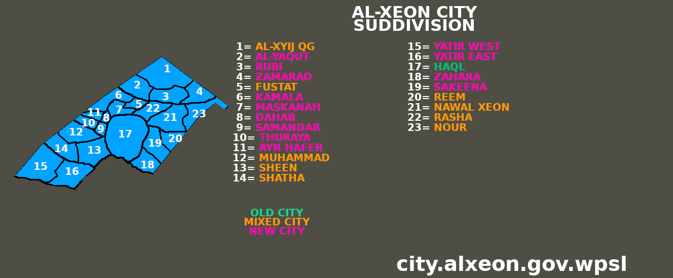
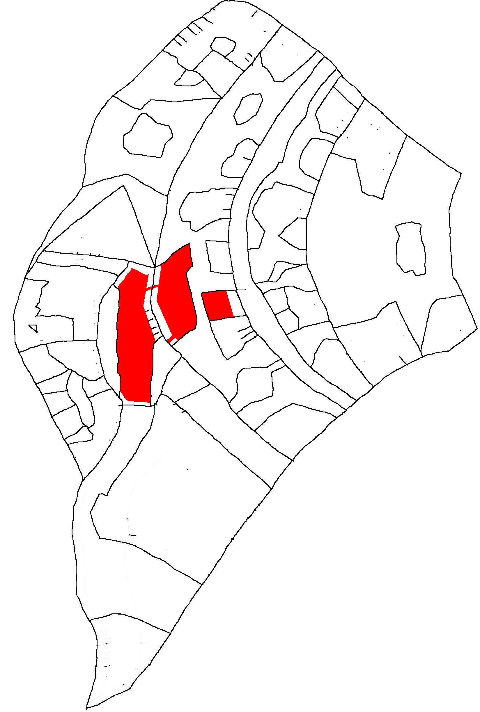
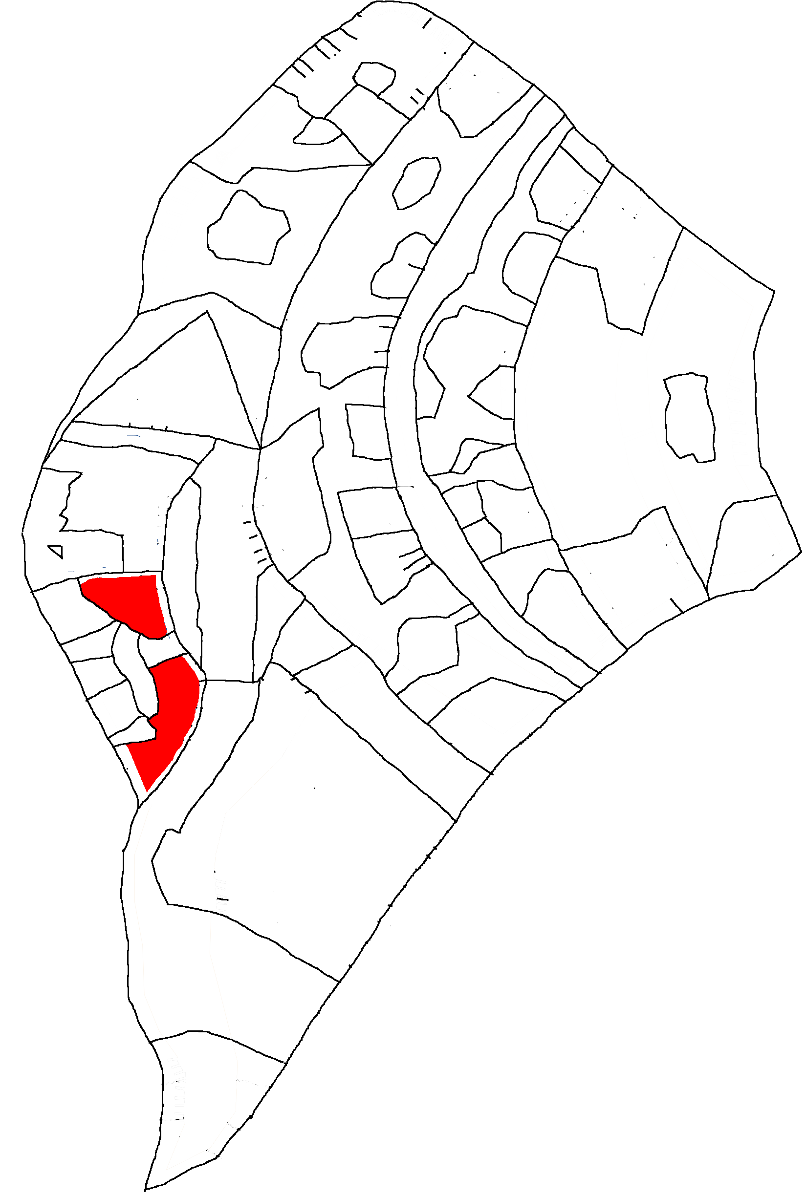
Administrative district of Al-Xeon and the homonymous Governorate located in the north-west of the city, in this district there is the administrative HQ and has an estimated population of about 504,000 inhabitants, where about 31% of the population of the region is concentrated in this district entire city, in this district there are both old and modern districts (as the former old city; in 2021 with the administrative reform the district of Al-Xeon HQ was divided into 4 parts (keeping the northern administrative part) while 3 others have been added which take the names of the former districts, namely: Al-Yaqut, Rubi and Zamarad while the former district will become a municipal area keeping the same name.
District which is part of the Municipal Administrative Area known as "Al-Xeon HQ" and has an estimated population of 145,000 inhabitants and is located on the western part close to the Mediterranean Sea; district created by the split of the district "Al-Xeon HQ" made by the administrative reform of 2021.
District which is part of the Municipal Administrative Area known as "Al-Xeon HQ" and has an estimated population of 123,000 and is located on the southern part of the municipal area; district created by the split of the district "Al-Xeon HQ" made by the administrative reform of 2021.
District which forms part of the Municipal Administrative Area known as "Al-Xeon HQ" and has an estimated population of 40,000 and is located on the eastern side abutting the A6 Highway and is close to the main entrance to the Port of Al-Xeon ; district created by the split of the district "Al-Xeon HQ" made by the administrative reform of 2021.
District located in the northeast of the city, the neighborhoods of this district were built in the years 1980-1990, this area of the city is quite important as it passes the highway that connects Al-Xeon with Al-Shula (Al-Wave) , where there is the Al-Xeon - Al-Plasma administrative border checkpoint; in the center of this district there is a district formed by various tunnels built in the 1970s in the old Al-Xeon which then between the years 2007 and 2017 were dismantled by Al-Taka (an area now separated from Al-Xeon in 2015) and transferred to Al'Azraq, the district has about 275,000 inhabitants; in 2021 with the administrative reform the Al'Azraq district was canceled and divided into districts that take the names of the former districts, namely: Nawal Xeon, Rasha and Nour while the former Al'Azraq district merged with the former district 'Ahmal Misbah becoming the Municipal Area "Al-Xeon East".
District located in the north-west of the city, the neighborhoods of this district were built recently between 2007 and 2018 where the majority is made up of recently built skyscrapers and modern buildings, where there are also shops and shopping centers of everything: aesthetics, cosmetics, information technology, technology, video games and much more; most of the population is under the age of 40, the district has been growing for almost 10 years and now has about 291,000 inhabitants; in 2021 with the administrative reform the district of Misahat was canceled and divided into districts that take the names of the former districts namely: Fustat, Kamala, Maskanah, Dahab, Sumandar, Thuraya and Ayn Hafer while the former district Misahat has become the "Al-Xeon West" Municipal Area.
District located in the east of the city, the neighborhoods of this district were built recently between 1990 and 2015 where the old neighborhoods were joined by new ones built in recent years and it is strategic because the highway passes through this district, this district too is part of New Al-Xeon, the district has about 244,000 inhabitants; in 2021 with the administrative reform the district of 'Ahmal Misbah was canceled and divided into districts that take the names of the former districts, namely: Zahara, Sakeena and Reem while the former district 'Ahmal Misbah merged with the former district Al 'Azraq becoming the Municipal Area "Al-Xeon East".
District located in the southwest of the city, the districts of this district were built recently between 2005 and 2019, where they were added to the rest of the city in order to drain the very overpopulated administrative district, this district is also part of the New Al -Xeon, the district has about 138,000 inhabitants; in 2021 with the administrative reform the district of Zajaz was canceled and divided into districts that take the names of the former districts: Muhammad, Sheen and Shatha while the former district Zajaz merged with the former district Yatir becoming the Area Municipal "Al-Xeon Sud".
District located in the extreme southwest of the city, the neighborhoods of this district were built recently between 2005 and 2019, as per Zajaz this district is an additional area of Al-Xeon city to outflow the very overpopulated administrative district, this district is also part of New Al-Xeon, the district has about 237,000 inhabitants; in 2021 with the administrative reform the district of Yatir was canceled and divided into districts that take the names of the former districts: Yatir West and Yatir East while the former Yatir district merged with the former Zajaz district becoming the Area Municipal "Al-Xeon Sud".
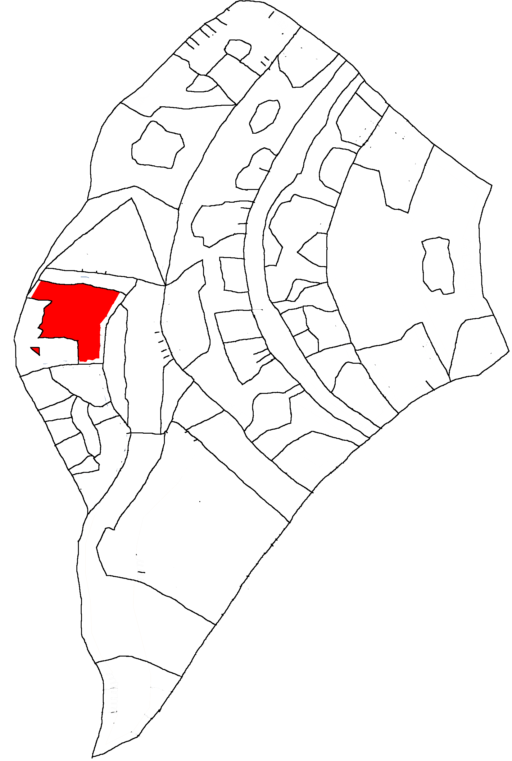
District located in the center of the city, the only landlocked district, the neighborhoods of this district were built in the last 30 years between 1984 and 2011, where there is a mixture of old city and new city, in this area of the city there is a large National Hospital, the district has about 54,000 inhabitants, the district is known to be very conservative where there is an average strongly religious population (although not like other Al-Xeon outlying areas), e.g. the city of Al-Taka southeast of Al-Xeon was part of this city until 2015 then WPS LOL decided to grant this city the status of a separate city by breaking away from Al-Xeon (becoming the third municipality of the Governorate after Al -Xeon and Mina'), where after this event the guerrilla warfare in the city of Al-Xeon (Popular revolts of Al-Xeon) stopped and the situation returned to normal.
Municipality Area Districts Population Surface Density Al-Xeon QG 4 504.000 734 sqkm 686 ab./sqkm Haql 1 54.000 405 sqkm 133 ab./sqkm Al-Xeon West 7 291.000 306 sqkm 951 ab./sqkm Al-Xeon East 6 519.000 786 sqkm 660 ab./sqkm Al-Xeon South 5 375.000 720 sqkm 521 ab./sqkm
District Municipality Area Population Surface Density Al-Xeon QG Al-Xeon QG 196.000 372 sqkm 527 ab./sqkm Al-Yaqut 145.000 122 sqkm 1.188 ab./sqkm Rubi 123.000 129 sqkm 953 ab./sqkm Zamarad 40.000 111 sqkm 360 ab./sqkm Fustat Al-Xeon West 42.000 38 sqkm 1.105 ab./sqkm Kamala 45.000 106 sqkm 424 ab./sqkm Maskanah 41.000 69 sqkm 594 ab./sqkm Dahab 34.000 27 sqkm 1.259 ab./sqkm Samandar 39.000 33 sqkm 1.182 ab./sqkm Thuraya 44.000 45 sqkm 987 ab./sqkm Ayn Hafer 46.000 42 sqkm 1.095 ab./sqkm Muhammad Al-Xeon South 44.000 125 sqkm 325 ab./sqkm Sheen 46.000 130 sqkm 354 ab./sqkm Shatha 48.000 105 sqkm 457 ab./sqkm Yatir Ovest 120.000 194 sqkm 618 ab./sqkm Yatir Est 117.000 166 sqkm 705 ab./sqkm Haql Haql 54.000 405 sqkm 133 ab./sqkm Zahara Al-Xeon East 94.000 105 sqkm 895 ab./sqkm Sakeena 78.000 125 sqkm 624 ab./sqkm Reem 72.000 107 sqkm 673 ab./sqkm Nawal Xeon 124.000 185 sqkm 670 ab./sqkm Rasha 66.000 98 sqkm 673 ab./sqkm Nour 85.000 166 sqkm 512 ab./sqkm Details
Al-Xeon (آل معالجان)
Location Country WPS LOL Republic Governorate Al-Xeon Administration Local Admin Faya Farasha Zyun (Black-Fuchsia Wave)
2019-2024 Official Languages Arabic, English Other Languages Italian, Turkish Territory Surface 3.005 sqkm Inhabitants 1.614.000 inhabitants Density 537 in./sqkm Height 0-40 m Climate Mediterranean Geographic Map 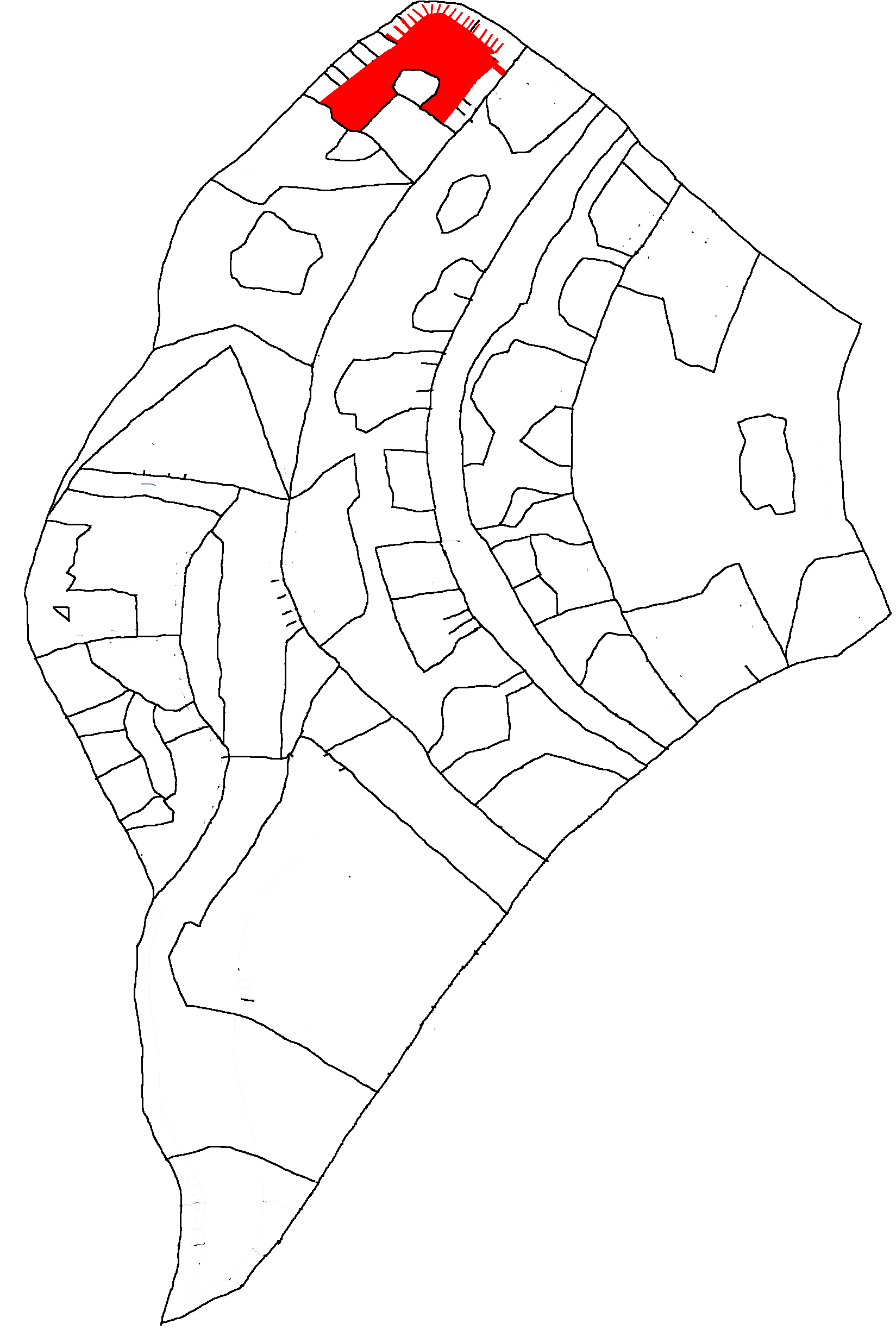
- Details
- Also available:
- Hits: 329
Al-Wave (موجة) in phonetic Arabic (Al-Mawjah) is the Metropolis of the North-West of the country located west of the black-fuchsia river, and was divided into 10 districts and 5 municipal areas even if they were divided into 61 neighborhoods , the capital of the governorate of the same name is located in the north-west of the country while the rest of the governorate is located in the far east of the country as a result Al-Wave is divided into 2 separate administrative areas (the eastern part is an enclave located in the eastern part of the country). Al-Wave was divided into 5 zones: Al-Wave North, Al-Wave Central, Al-Wave West, Al-Wave East and Al-Wave South; the old and new city is mixed according to the districts where the oldest area of the city is Saliwah located in the south of the metropolis even though the old city is in the north of the administrative district. Al-Wave city dates back to 1918 where Al-Saliwah city was established (in the south of present metropolis) then later in 1982 Al-Wave city was established and Al-Saliwah area was annexed where the Al-Wave HQ district was created in the exact center of the metropolis (still in those days it was a vast desert that connects the Mediterranean Sea to the black-fuchsia gulf), the city between the years 1980 and 2010 underwent a rapid urbanization process where a metropolis sprang up from the desert thanks to many investments (between 1990 and 2005 during the civil war the city suffered few bombings), in 1984 the districts of Zahara were created (where the state heliport was also built which was recently abandoned due to inactivity), in 1988 the districts were built: Fawdaa, Specter and Xor (in the south of the city) which were an extension of the city of Al-Wave (where old and new districts mix) while the new city was built between 2008 and 2020 where the districts of: Kiara (in the north-west) and Aylyna (in the north-east) were built between 2012 and 2016 and finally the district of New Al-Wave (New Al-Wave) between 2017 and 2021. Al-Wave was initially a very poor city and a classic city where there were only a few groups of inhabitants scattered across a vast desert, in 1990 there were about 80,000 inhabitants and in those years between 1990 and 2010 the city underwent a rapid urbanization process which will also have an economic explosion between 2006 and 2015 to become from a small town to a large metropolis which in 2013 will surpass WPS LOL City in population and also in GDP per capita wealth becoming in 30 years from the poorest city to the richest one by making a revolution attracting many investors, the city will go from 80,000 inhabitants in 1990 to about 1.20 million inhabitants in 2006, then it will also have a demographic explosion until it exceeds 5 million inhabitants (but after 2019 the city will start to have a decline in population as the city used to be a giant refugee camp and other cities have better services especially the administrative capital which in 2023 will take back the scepter as the most populated city in the country besides the fact that Al-Wave has too many neighborhoods built badly, where there are still too many slums and very degraded areas that do not attract much where the population is divided on many issues). The population of this city is mostly female where it reaches about 75% of the population between 14 and 45 years of age on average; but after years of prosperity around the years 2008-2019, the city of Al-Wave will have a sharp economic and demographic slowdown and will no longer have the same growth as both the capital: WPS LOL City and the cities of Al-Plasma and Al -Kremisi will have continuous growth as well as strategic positions with respect to Al-Wave; even High Tech and video game companies and organizations have moved to other cities, where the economy has started to decline, slipping a few places; however there are entire neighborhoods where there are XXX Areas where the Mistresses and Slaves live (in these environments 90% of the women are in charge) where the WPS LOL has revolutionized the economy of this city. As regards religion, in the city of Al-Wave the majority of the population professes to be non-religious with at least 50% atheists/agnostics, 35% Muslims (90% of these non-practicing) and a remaining 15% other religions (where there are Christian and Jewish minorities). The population is 5.12 million (the second largest city in the country). Al-Wave City skyline overlooking the Mediterranean sea. The city of Al-Wave has been administered since 1982 (before the establishment of Al-Wave the city was only a group of tribal villages with a small town governed by a chief of tribal peoples: Al-Saliwah who today represents the southern district of Al-Wave and dates back to 1918, before this year there was almost nothing and it was a vast desert), the city from 1982 to 2007 was administered by a local council of a King who was mixed between the rabbit of the Government of the British colony and the Italian-Arab rebels, after the fall of the English colony the elective power of the mayor is decided by the people under democratic elections. Between 1918 and 1982 the city was governed by tribal chiefs who could be kings, village chiefs, local councils or candidates under various requirements; with the foundation of the city of Al-Wave comes the creation of a Local Council of Al-Wave with targeted candidates chosen by the mixed governing council decided by a King with both British and Italian-Arab rebel influence; starting from 2007 during the foundation and democratic transition of the WPS LOL Republic democratic elections decided by the people are created for the first time where the first election was won by Karim Al-Mawjaryn (mayor chosen by both the tribals and a coalition of mixed parties who can be both conservatives and seculars), in 2012 surprisingly the female candidate wins who is part of a coalition between locals and secular progressives where the "White-Fuchsia" Coalition is created which wins the elections by choosing a woman excluding the conservatives; thanks to this election the city had both a demographic and economic explosion to become in a few years the richest city in the country, thanks to a radical change; in 2015 a girl chosen by the WPS LOL was elected (another friend of the admin) or Aylyna Fawdaa Al-Hamra coming from a totally secular and progressive family and she is the candidate of the Onda Nero-Fuchsia secular party which obtains 58% of the votes in the 2015, tearing the city away from both locals and conservatives, the mayor will be confirmed for a second term in 2018 with 69% of the votes with an almost overwhelming majority; In 2021 there will be no elections due to a lack of candidates only in the Administrative elections of Summer 2021 (the elections have been postponed to Autumn 2019 where the outgoing mayor will run for Governor of Al-Wave, where the Conservatives will struggle in the local administrations to find a candidate while Kiara Al-Bayeek, a non-practicing Muslim girl of Egyptian origin, is running from the progressive side. She will take the place of Aylyna Fawdaa Al-Hamra, where she will obtain 58% of the vote (a sharp decline for the black-fuchsia party compared to the earlier). 1918-1982 (Tribal Chiefs) Al-Wave QG Old Al-Wave (Al-Qadin Al-Mawja) "New Al-Wave" (Al-Jadid Al-Mawja) "Kiara/Kiaarana" "Aylyna" Ghost (Al-Tayf) Zahara Fawdaa Saliwah Xor (Ziur) Al-Wave SkylineAbout

Al-Wave Policy
1982-2007 (Al-Wave Local Council)
2007-2012 (Karim Al-Mawjaryn) Green Conservative Party 65%
2012-2015 (Layla Jamyla Al-Waleed) Al-Wave Local Party + Fuchsia Wave 51%
2015-2018 (Aylyna Fawdaa Al-Hamra) Wave Black-Fuchsia 58%
2018-2021 (Aylyna Fawdaa Al-Hamra) Wave Black-Fuchsia 69%
2021-2025 (Kiara Al-Bayeek) Wave Black-Fuchsia 58%Al-Wave Policy

Administrative district of Al-Wave and the homonymous governorate, in this district there is the administrative HQ, located in the city center of the metropolis and has a total population of about 1,820,000 inhabitants and it is the most populated district in the country (in addition to being the densest area of the city), within it there are 5 sub-districts where a tributary passes which is an extension of the Fuchsia-Black River.
Al-Wave old city district established in 1982 with the foundation of the city of the same name, although it is not chronologically the oldest area (but only the second), where the first neighborhoods were founded in 1982 in this district north of the administrative area but always in the city center and has a total population of 92,000 inhabitants, the uni
Al-Wave New Town District established in 2015, it is the most modern district of the metropolis located in the eastern area of Al-Wave and has a total population of 1,655,000 (it is the second densest area of the metropolis) and is located on the coast of the western Black-Fuchsia River; in 2021 with the administrative reform the district of New Al-Wave was canceled and transformed into a municipal area which includes the districts formed by the former districts namely: Xor, Kiarana, Bab Yusuf, Bab Yazeed, Bab Thaabit, Bab Zahid, Bab Tarfah, Bab Tamal, Bab Riyadh, Aylyna Iman, Aylyna Jumaana, Aylyna Ikraam, Aylyna Ibtihaaj, Aylyna Hooriya, Aylyna Hayat, Aylyna Haifa where the former districts of Kiarana and Xor were also absorbed into the municipal area.
District located in the west of the city, bathed by the Mediterranean Sea and has a total population of 350,000 inhabitants, the name of the district is a reference to a Goddess who was called "Chiara" and was part of a Neapolitan mythology then emigrated to the Arab world where its name was changed to "Kiaarana" and the district has both the Arabic and Italianized name "Kiara"; this district is part of the new city although it is an enclave within the old city; in 2021 with the administrative reform the district of Kiarana was absorbed by the municipality of New Al-Wave.
District located in the east of the city, has a total population of 454,000 inhabitants (it is the fourth densest area of the metropolis) and is located on the coast of the western Black-Fuchsia River and is part of the new city, the name of the district is a reference to a goddess who was called "Elena" and was part of a Greek mythology which then emigrated to the Arab world where her name was changed to "Aylyna" and the district has both Arabic and Italian names; it is on average one of the richest districts of the metropolis; in 2021 with the administrative reform the district of Aylyna was absorbed by the municipality of New Al-Wave.
District located in the western part of the city, has a total population of 345,000 inhabitants and is located a few steps from the Mediterranean Sea; it is part of the old city of Al-Wave and is famous for numerous districts full of slums built between the years 1990 and 2000 to handle millions of refugees during the war of independence, in fact it is quite a degraded area of the city also due to unauthorized building for at least 10-15 years; in 2021 with the administrative reform the Specter district was canceled and transformed into a municipal area known as "Al-Wave West".
District located in the west/north-west part of the city, it has a total population of 314,000 inhabitants and is also located a few steps from the Mediterranean Sea; is part of the old city, an important area because it serves a military Helipad used between the years 1980 and 2010 (the heliport lost much importance after the WPS LOL City Helipad was built in the capital), in this district there are many companies and organizations and is the only area of the old city not degraded as it is close to the new city; in 2021 with the administrative reform the district of Zahara was canceled and transformed into a municipal area known as "Al-Wave West".
District located in the southwest of the city, has an estimated population of 580,000 inhabitants (this is the second densest area of the metropolis, where it is one of the most overpopulated districts of Al-Wave), the district borders the city of Qurmuzi (Al -Kremisi) and there are administrative borders between Al-Wave and Al-Kremisi; in this district old neighborhoods are mixed with new neighborhoods, but the slums are not lacking however less degraded areas are present in this area of the city; in 2021 with the administrative reform the Fawdaa district was canceled and transformed into a municipal area known as "Al-Wave Sud".
District located in the south of the city, it has an estimated population of 335,000 inhabitants, it is the oldest district since the foundation of Al-Wave, it dates back to 1918 (although there were already around 1860 the first settlements) where until 1982 it was a city on its own, then it was annexed to the current metropolis, it is one of the poorest and most degraded districts of the city on average (although in recent years the situation has been constantly improving), there are still various problems and unemployment, the district of Saliwah borders the northern neighborhoods of Al-Kremisi North; in 2021 with the administrative reform the Saliwah district was canceled it is transformed into a municipal area known as "Al-Wave Sud"
District located in the south-east of the city, it has an estimated population of 280,000 inhabitants and is part of the new city where there are some old but sparsely inhabited districts; in 2021 with the administrative reform the district of Xor was canceled is transformed into a municipal area and was annexed to the area of "New Al-Wave".
Municipality Area Population Surface Density Al-Wave QG 1.720.000 392 sqkm 4.462 ab./sqkm Old Al-Wave 94.000 259 sqkm 363 ab./sqkm Al-Wave Ovest 659.000 751 sqkm 877 ab./sqkm Al-Wave Sud 915.000 750 sqkm 1.220 ab./sqkm New Al-Wave 1.655.000 1.842 sqkm 898 ab./sqkm
Districts Municipally Area Population Surface Density Al-Wave QG Al-Wave QG 1.720.000 392 sqkm 4.462 ab./sqkm Old Al-Wave Old Al-Wave 94.000 259 sqkm 363 ab./sqkm Saliwah Al-Wave South 359.000 387 sqkm 866 ab./sqkm Fawdaa 680.000 363 sqkm 1.598 ab./sqkm Spettro Al-Wave West 341.000 385 sqkm 896 ab./sqkm Zahara 330.000 366 sqkm 858 ab./sqkm Xor New Al-Wave 220.000 236 sqkm 1.186 ab./sqkm Kiarana 380.000 342 sqkm 1.023 ab./sqkm Bab Yusuf 105.000 89 sqkm 944 ab./sqkm Bab Yazeed 94.000 90 sqkm 944 ab./sqkm Bab Thaabit 89.000 78 sqkm 1.000 ab./sqkm Bab Zaahid 85.000 76 sqkm 1.039 ab./sqkm Bab Tarfah 97.000 86 sqkm 977 ab./sqkm Bab Talal 68.000 80 sqkm 825 ab./sqkm Bab Riyadh 96.000 98 sqkm 969 ab./sqkm Aylyna Iman 128.000 198 sqkm 621 ab./sqkm Aylyna Hayat 95.000 223 sqkm 690 ab./sqkm Aylyna Haifa 140.000 246 sqkm 719 ab./sqkm Details
Al-Wave (موجة)
Location Country WPS LOL Republic Governatorate Al-Wave Administration Local Admin Kiara Al-Bayeek (Black-Fuchsia Wave)
2021-2025 Official Languages Italian, Arabic Territory Surface 3.994 sqkm Inhabitants 5.121.000 inhabitants Density 1.506 in./sqkm Climate Mediterranean/Desertic Geographic Map
- Details
- Also available:
- Hits: 351
Al-Spektro (مدينة الأشباح) in phonetic Arabic (madinat al'ashbah) also called "Neo Lavander City" or "New Lavander" in phonetic Arabic (madinat lafandar aljadida) is a city located in the extreme southeast of Al Governorate -Wave and also in the extreme southeast of the country (the largest city in the east of the country), and is divided into 7 districts. The city of Al-Spektro dates back to 1972 where it was founded a few decades before the civil war (initially it was a military area where there is still today a Fort just north of the city, the strategic position was important for the British who created the colonizing the city but the colonial control did not last long, where the rebels conquered it towards the end of the 1980s also helped by other Italian rebels who landed in those years who were deserters who had fled from Italy, where there was also a very strong Italian migration into the country from various countries where Italian is the mother tongue but also Italian-speaking, the Arabs mixed with the Italians, thanks to the Italian migration in the country (especially in the eastern/south-eastern area) the area of the country had an exponential economic growth without previous years, from 8,000 inhabitants in 1972 to 78,000 inhabitants in 1990 (where the population grew by 94%, then there was a slow growth between 2006 and 2015 after which the population in the region returned to growth thanks to the many improvements made by the WPS LOL), after 2019 it had one of the highest economic and demographic growth in the world, becoming in a few years the fourth richest city where by 2025 the population could touch one million inhabitants. The eastern area of the WPS LOL Republic became an area where many refugees from Italy, Europe, America, North Africa and the Middle East in this vast desert area there were, in addition to refugees, numerous military areas and depots for the Italian-Arab rebels , over 500,000 inhabitants who fled the conflict who mixed with refugees found refuge, the city of Al-Spektro like all the other towns in the eastern area of the country date back to about 40 years ago, as they were recently built (before they were a vast uninhabited desert) and the whole eastern area of the country had to face a mass migration where from Italy and Arab countries, however it brought benefits to the country's economy thanks to a lot of money inflow with urban and industrial improvements the whole region had a growth exponential although with a process of "Italianisation" of the south-eastern part of the country. The city of Al-Spektro until 2008 was a very conservative and poor city, then after the numerous investments of WPS LOL in the southeast area of the country, there was an economic explosion with +500% where the GDP per capita arrived from 8,400 EUR in 2008 to the current 45,000 EUR in 2022 becoming a financial and port center thanks also to Arab and Italian investors who created a mini-Italy, the current population is very progressive where conservatives are less and less even the new generations support the black-fuchsia revolution, but there is also a strongly right-wing 30% of the population. In 2020 the WPS LOL has decided to build "The Lavander Skyscraper" or the skyscrapers of Lavandonia with reference to the famous ghostly city of the Pokémon world where between 2020 and 2022 8 skyscrapers will be built throughout the skyline of the city, where there are many also important companies of foreign information technology such as SONY, Asus, Huawei and is currently the richest city in this area of the country with a strategic position, there is also the HQ of the most important XXX site in the world or XHamster (the black-fuchsia of this multinational) where it is a skyscraper that is based not only on the management of the Servers but there are many Porn activities obviously with strict regulations, apartments for legalized prostitution, areas for each type of Porn where there are very frequent as well as the ID Card check and is VM15 (minors of this age cannot access it); this city due to its very large extension will have a demographic explosion in the next 10 years which will attract both foreigners and inhabitants of the same country. Al-Spektro has 30% of population support Italian Fascism or at least Nationalism where WPS LOL welcomed them where plans to overthrow the Italian Republic in the near future to liberate Italy from western imperialism (in WPS LOL Republic Fascism is not illegal as long as it has a democratic system and has no extremism). The population is approximately 654,000. The city of Al-Spektro has been administered since 1994 (before this year there was only desert in this area of the country and the whole eastern area of the country known as "Desert Waves" suffered a strong migration of Italians in the country, causing the Italianization of a large part of the WPS LOL Republic, between 1994 and 2007 the city was administered by a local council decided by the King and the tribal locals of the area; starting from 2007 the city is administered by a mayor elected in democratic elections (although the power of mayors in rural and peripheral areas is less than that of mayors in capital cities, at least until 2015 after which all mayors in the country will have equal power in every city. After the establishment of democratic elections, the first mayor was Sair Al-Shab an Islamic conservative elected with 69% where at the time the population was still very conservative, then after 2009 it changed and became less and less conservative; in 2012 another conservative but on average more secular mayor was elected where he obtained 65% of the votes against the independent challenger supported by secular progressives who took 29%; in 2015 a socialist party known as the Red Reformist Party was elected for the first time which took 54% where supported by the progressive secularists it obtained the victory while the conservatives stop at 42%, from there the conservative collapse begins in the area of the country which veers towards secular progressives; in 2018 Daniel Spettro (one of the founders of WPS LOL and a great friend who together created all this) where he is also striker of the WPS LOL City football team (WPS LOL City 2006) where he obtained 58% of the votes with the party Onda Nero-Fuchsia (BFWP), the outgoing mayor will be reconfirmed for a second term with 74% of the votes (about +16%) being one of the most wanted local administrators. 1972-2007 (Tribal Chiefs) Al-Spektro QG Misurata Emesa Tiberine Saragina JisrAbout

Al-Spektro Policy
2007-2012 (Sair Al-Shab) Green Conservative Party 69%
2012-2015 (Karim Al-Mawjaryn) Green Conservative Party 65%
2015-2018 (Albert Palermo) Red Reformist Party 54%
2018-2021 (Daniel Spettro) Wave Black-Fuchsia 58%
2021-2025 (Daniel Spettro) Wave Black-Fuchsia 74%Distretti di Al-Spektro
District Municipality AArea Population Surface Density Al-Spektro QG Al-Spektro 234.000 354 sqkm 661 ab./sqkm Misurata 45.000 154 sqkm 292 ab./sqkm Emesa 74.000 307 sqkm 241 ab./sqkm Tiberina 125.000 329 sqkm 380 ab./sqkm Saragina 82.000 370 sqkm 222 ab./sqkm Jisr 94.000 220 sqkm 427 ab./sqkm
Administrative district of the city of Al-Spektro located in the city center, in 2008 the municipality of the city was created, it is the most populous district with at least 234,000 inhabitants where the HQ of Al-Spektro located in the city center; with the administrative reform of 2021 the city of Al-Spektro was divided into 6 districts namely: Al-Spektro HQ, Misrata, Emesa, Tiberina, Saragina and Jisr.
District located in the western part of Al-Spektro, the smallest in extension where there is only one skyscraper which is both a residential area and an Italian supermarket, the district reaches 45,000 inhabitants and is a reference to the Libyan city of Misrata.
District located in the northwest of the city and facing the desert to the north and is still under construction where there is currently an estimated population of 74,000 inhabitants, there are at least 3 skyscrapers and numerous residential areas and Italian companies that have moved from Italy against the absurd high cost of living in the former beautiful country, Emesa is a reference to the city of Homs in Syria (which in Roman times was called Emesa).
District located in the north-east of the city and overlooks both the desert and the sea where a port is under construction, the population of this district is 125,000 inhabitants and it is a very densely populated area, the district is full of Italians and Arabs where there are 3 skyscrapers and at least 20-30 residential areas but there are also both Italian and Arab companies, Tiberina is a reference to the Tiber Island which was the home of the assissini in 1500 in Rome when they fled from Tuscany due to the temporary siege of the Borgias and took refuge on the Tiber island to reform the army and arm themselves for the counterattack to recover the lost territory, there are Isu minorities who are descendants of a militia of "those who came before" who are the ancestors of the assassins.
District located in the southeast of the city overlooking the sea and the A6 motorway which connects the east of the country with the center of the country; it is a district still under construction where it currently has 82,000 inhabitants (but in the coming years we will have to face yet another demographic boom where apartments, skyscrapers, buildings and neighborhoods are being built as well as numerous companies where numerous jobs are expected for refugees; Saragina is a reference to an ancient military area in the Green Mountains which was an area in Eastern Libya where it was in dispute between the Romans and the Egyptians just before 10 BC where after the Alexandrian civil war, Egypt surrendered to the Roman Empire by laying down their arms.
District located southwest of the city facing the western sea and the A6 motorway which connects the east of the country with the center of the country; this is also a district under construction which currently has 94,000 inhabitants, but is in perspective of facing another demographic boom expected in the next 10 years, the majority of this district is populated by Arabs (there are few Italians), but many companies they are Italian.Details
Al-Spektro (شبح)
Neo Lavander City (مدينة لافاندر الجديدة) Location Country WPS LOL Republic Governatorate Al-Wave Administration Local Admin Daniel Spettro (Black-Fuchsia Wave)
2018-2025 Official Languages Arabic, Italian Territory Surface 1.734 sqkm Inhabitants 654.000 inhabitants Density 377 ab./sqkm Climate Mediterranean/Deserticic Geographic Map
- Details
- Also available:
- Hits: 321
Al-Plasma (البلازما) in phonetic Arabic (Al-Balazima), historically also called "Plazma" is the Metropolis of the Center of the country located in the central part east of the black-fuchsia river and west of the Al-Plasma Desert (made except for an area that is across the sea that divides the governor of Al-Plasma in 2; and it is also an autonomous city with a regional government and is divided into 27 districts (9 of these are located in the eastern part of the city overlooking the desert of Al-Plasma or the new city), the city is a kind of island (also called "Al-Plasma Island") within the archipelago as it is not physically connected where the connections are by bridges crossing the sea and the river while southeast of Al-Plasma is the desert of Al-Xyij separated by the Al-Plasma River. The city is divided into 6 zones: Al-Plasma HQ, Fawdaa, Raqamia, Al-Qarsana, Old Al-Plasma and New Al-Plasma; and is divided into 27 districts (18 in the western part and 9 in the eastern part); in 2021 due to the administrative reform the previous 6 districts were transformed into municipal areas while the neighborhoods became districts which split the districts from 6 to 27. In this city there is the organization which is also a Military Militia called "Team Plasma". The population is 4.18 million (third largest city in the country). Al Plasma skyline. The city of Al-Plasma dates back to 1567 which had previous denominations: Plazma and Balazima (name still used in Arabic language), although the city was only politically established in 1947, the city has had various Mediterranean and Arab cultural influences (also partly Turkish and recently also Italian), the city in the 1940s and 1990s was heavily bombed by the British (in the city center which was completely destroyed, the north and south areas suffer less damage), the city was rebuilt 2 times where many neighborhoods were rebuilt from scratch (in fact the city center assumes a mixed effect between ancient and modern areas), when Al-Plasma was established the 2 districts were created: Fawdaa and Al-Plasma HQ (in the north of the city) where the old city in the south of the city, around 1961 the Raqamia district was created in the exact center of the city, finally in 1989 the construction of the Al-Qarsana district began in the central-south of the city close to the old city which will later become the most populated of the metropolis (until 2019), finally in the 2010s the last district named: New Al-Plasma was built which was built on the other side of the sea to the east of the city close to the eastern desert which it will attract many investors and become the most populous district of the city. Despite the conflicts and destructions and then reconstructions, the city of Al-Plasma has never fallen since its foundation where neither the Ottomans nor the British have ever managed to conquer it, the city of Al-Plasma has always been independent (apart from the interlude between 1990 and 2006 where the soldiers of Al-Plasma deliberately joined the Italian-Arab rebels to expel the British invaders from the country), it is said that the Admin of WPS LOL immigrated to this city in a district of the Al-Qarsana district via speedboat from Italy in the 2000s where he grew up in this city and founded both Team Plasma and WPS LOL anti-imperialist coup is organized. Al-Plasma in the 1990s and early 2000s had a completely destroyed economy with many popular uprisings, where WPS LOL invested 2.5 trillion to rebuild the city by making many investments and within 15-20 years the city of Al- Plasma from one of the poorest cities in the Mediterranean becomes the third economy of the WPS LOL and one of the richest in the Mediterranean making a revolution becoming an industrial pole of the Mediterranean; Al-Plasma is considered the most secular and progressive city in the country (where traditional and conservative parties have always had little support in this city, in fact Al-Plasma is considered the main fiefdom of the Black-Fuchsia Revolutionary Party of WPS LOL), a due to its strategic location, by 2030 the city of Al-Plasma could surpass even the capital when it comes to wealth. Starting from 2015 there was a constitutional reform between WPS LOL and Team Plasma where the metropolis became an autonomous city in exchange for the military merger between the WPS LOL Army (WPSLA) and Team Plasma which from military militia became WPS special force LOL and there was the transformation of the Governorate from Special Statute (semi-autonomous) to Autonomous. In September 2020, the WPS LOL decided to create the Metropolitan City of Al-Plasma also called "Greater Al-Plasma" which also includes the cities of Taqat, Almas and Mutaeaddid Al-Alwan where it is only at observation level but nothing of politic. The city of Al-Plasma has been administered since 1947 (before that year the city had no mayors but rulers, kings, princes or any candidate (who was not religious, as Al-Plasma policy forbade administrations based on religious infiltration in politics), before the establishment of Al-Plasma the city was administered by heads chosen by the King of the city-state until 2005 after which the monarchical system where the mayor is decided by the people under democratic elections was abolished. Between 1567 and 2005 the Al-Balazima dynasty ruled in Al-Plasma, between 2005 and 2007 there was no mayor as the country was facing the democratic transition, the first democratic election was in 2007 and was won by a coalition of conservatives (albeit not too backward) where the candidate was mostly mixed (i.e. chosen from both sides: conservatives and progressives), in 2011 the local Team Plasma won the election in the city of Al-Plasma where a period of radical change for the city that was under reconstruction while in 2015 a girl was elected for the first time by the admin of WPS LOL as she is a friend of his or Federika Al-Vorel who ran for the Onda party Black-Fuchsia winning with only one list, snatching the city from the locals where in 2015 it had 54% of the votes while in 2017 it had 68%, where it brought a great renewal to a city which in the years to come will become one of the richest cities in the country and also the most secular and progressive city in the country; unable to run for a third term, the former mayor decided not to run for the mandate of Governor of Al-Plasma and withdrew from the political scene where she decided to open a company of closed houses for the city of Al-Plasma; in 2021 another cousin of the Admin appears or Franshiska Tasynsun (sister of her favorite cousin who is mayor of Al-Martyx) and runs for the Onda Nero-Fuchsia party (BFWP) easily winning the local elections of Al-Plasma with a 74%. 1567-2005 (Al-Balazima Dynasty) Al-Plasma HQ Bashir-Muhammad-New Fawdaa (Formerly "Fawdaa") Bab Homs-Lamya-Ikraam-Ruqaya-Nour-New Raqamia-Suhair (Formerly "Raqamia") Bab Hadiya-Zahara-Musheera-Azeza-Tamadhur (Formerly "Al-Qarsana") Old Al-Plasma NPL [Niuun/Bab Samar/Bab Yasmeen/Shabh/Bab Izdihaar/Tarfah/Ziyad/Al-Balyan/Taqat Plasma] (Formerly "New Al-Plasma") Al-Plasma Skyline About

Al-Plasma Policy
2005-2007 (Al-Plasma Local Council)
2007-2011 (Samyr Al-Balyzm) Green Conservative Party 52%
2011-2015 (Vincenzo Mavil Bassil) Party Team Plasma 60%
2015-2017 (Federika Al-Vorel) Wave Black-Fuchsia 54%
2017-2021 (Federika Al-Vorel) Wave Black-Fuchsia 68%
2021-2025 (Franshiska Tasynsun) Wave Black-Fuchsia 74%Al-Plasma Districts

Administrative District of Al-Plasma and the homonymous Governorate, in this district there is the Administrative HQ and it has an estimated population of 894,000 inhabitants (60% of the inhabitants are members of the "Team Plasma" militia where 90% of the district are all ultra-modern skyscrapers but the remaining 40% of the inhabitants are citizens); the district is located in the extreme north of the city and is surrounded by the Black-Fuchsia River except the southern part where it borders with other districts and to the southwest is the Western Al-Plasma Desert, this district dates back to 1947 when it was established the city of Al-Plasma where the municipality was created.
District located in the central-north of the metropolis, most of the district is made up of old buildings built during the post-war period of the 1940s, where this area of the city suffered serious damage from the war between 1990 and 2006, so that many districts have been reconstructed in a modern way making an area of Al-Plasma mixed between the tradition and the modernity, the estimated population of this district is 395,000, along with the administrative district was founded in 1947 with the establishment of the city, this district has had numerous problems of degradation and relative poverty (although not at the levels of many other poor areas of the country); where only after 2014 it returned to normal where the neighborhoods of the New Fawdaa district were built; with the administrative reform of 2021, the Fawdaa district was canceled and is divided into 4 districts that take the names of the neighborhoods that subdivided this district, namely: Bashir, Muhammad and New Fawdaa (while Fawdaa has become a municipal area of Al-Plasma).
District of the city located in the center of the metropolis, most of this district is similar like Fawdaa i.e. old buildings mixing with new ones, the district was established in 1961 simultaneously with Raqamia of Al-Kremisi city by a parallel government established by the anti-imperialist premises with the aim of expelling the British in 1961, compared to Fawdaa, this district is on average more modern and avant-garde, where the damage during the conflict between 1990 and 2006 suffered little damage compared to other northern areas of the metropolis as only 50% of the area has been completely destroyed, subsequently there have been investments for the reconstruction also financed by foreign investors, the population of this district is 660,000 inhabitants, in this area of Al-Plasma concentrates part of the 'entertainment, nightlife, technology and good modernity; with the administrative reform of 2021, the district of Raqamia was canceled and is divided into 7 districts that take the names of the neighborhoods that subdivided this district, namely: Bab Homs, Lamya, Ikraam, Ruqaya, Nour, New Raqamia and Suhair (while Raqamia has become a Municipal Zone of Al-Plasma); in recent years old buildings and degraded neighborhoods have been demolished in the Raqamia area, also demolishing numerous slums and in its place modern skyscrapers and new neighborhoods have been built, greatly improving the economy of the city center of Al-Plasma.
District of the city located in the central-south of the metropolis, it was the most populated district of Al-Plasma (before 2019 where it was then overtaken by the District of New Al-Plasma and later also by the former district of Raqamia) with a population of about 420,000 inhabitants (the population in the last 10 years has greatly reduced due to poor services in most of this former district near the old city of Al-Plasma where they changed district), most of the neighborhoods in this district have been built in the last 20 years between 1994 and 2005 where 30% of the economy of the metropolis was concentrated (while the former district was founded in 1989), overlooks the old city district to the south and the desert to the east, initially in this district there were many activities and there was prosperity with a future perspective but due to the never finished projects with even rigged tenders, the district lost many investments and began to deteriorate with an impoverishment of the neighborhoods with the exception of "Zahara" the sports area where there is the Al-Plasma Stadium which is the only area where wealth holds, this district suffered very little damage in the conflict between 1990 and 2006, Al-Qarsana is a district where there was only an Arab influence beyond to the Italian one as 40% of Italians live there, in recent years the district is experiencing a constant decline in population where many inhabitants emigrate to the district of Raqamia and New Al-Plasma; with the administrative reform of 2021, the Al-Qarsana district was canceled and divided into 5 districts that take the names of the neighborhoods that subdivided this district, namely: Bab Hadiya, Zahara, Musheera, Azeza and Tamadhur; recently, after years of waiting 2020, the WPS LOL has taken steps to make loans to refurbish degraded neighborhoods where to curb the loss of population where it asks for the demolition of all slums and old neighborhoods in exchange for modernizing the entire former district.
District of the old city located in the south of the metropolis, dates back to the period of the foundation of the old Plazma dating back to 1569, where there was a succession of Ottoman, Turkish, English and finally Arab domination, the old city of Al-Plasma maintained a good cultural imprint even today where there is a part of the population that is conservative however has always been very open as historically Al-Plasma has always had a secularized imprint where culture mixes with progress, even if young people have mostly moved to other districts , this district has an estimated population of approximately 380,000.
District of the new city located in the east of the metropolis close to the eastern desert of Al-Plasma and is a kind of enclave separated from the rest of the metropolis, it is the most recent district and built between 2010 and 2020 (still under construction development), where the majority of the population is 14-41 years of age, in this area of the city the only 100% new and avant-garde neighborhoods where entertainment reigns, nightlife, but also information technology and is the second most important district of Al-Plasma which has been growing for over 10 years where over 2,000 billion have been invested, where it has become a financial and industrial center of the Mediterranean, this district is the most modern of the entire metropolis, 90% is formed by ultra-modern skyscrapers made of fiberglass of particular and different shapes, the only connection of the New Al-Plasma district is only with the administrative district of Al-Plasma HQ (although a second connection with the south is under construction of the city of Al-Plasma near the area of Al-Qarsana), in this district the places of worship are less than 0.01% as 98% of the population is non-religious where the minority is Muslim but not practicing, this district has an estimated population of about 1,087,000 inhabitants (the population has been growing since 2014 where many inhabitants of the same city also move to this district), in recent years it is also having a migration from the western part of the city where they were built numerous neighborhoods then transformed into districts after the administrative reform of 2021 namely: Niuun, Bab Samar, Bab Yasmeen, Shabh, Tarfah, Ziyad, Al-Balyan and Taqat Plasma and is currently the most populated district of the entire city, the former district of New Al-Plasma was divided into 9 districts which took the names of the neighborhoods that subdivided that district while the former district of "New Al-Plasma" was transformed into a Municipal Zone; in this area of the city of Al-Plasma there are many financial and technological activities and also many luxury apartments.
Municipality Area Population Surface Districts Density Al-Plasma QG 994.000 410 sqkm 1 2.424 ab./sqkm Fawdaa 395.000 345 sqkm 4 1.145 ab./sqkm Raqamia 680.000 494 sqkm 7 1.376 ab./sqkm Al-Qarsana 420.000 445 sqkm 5 944 ab./sqkm Old Al-Plasma 380.000 300 sqkm 1 1.267 ab./sqkm New Al-Plasma 1.207.000 1.748 sqkm 9 690 ab./sqkm
Districts Municipality Area Population Surface Density Al-Plasma QG Al-Plasma QG 994.000 410 sqkm 2.424 ab./sqkm Bashir Fawdaa 42.000 72 sqkm 583 ab./sqkm Muhammad 48.000 74 sqkm 649 ab./sqkm New Fawdaa North 128.000 99 sqkm 1.293 ab./sqkm New Fawdaa South 177.000 100 sqkm 1.770 ab./sqkm Bab Homs Raqamia 45.000 89 sqkm 506 ab./sqkm Lamya 47.000 80 sqkm 587 ab./sqkm Ikraam 37.000 85 sqkm 435 ab./sqkm Ruqaya 50.000 48 sqkm 1.042 ab./sqkm Nour 94.000 68 sqkm 1.382 ab./sqkm New Raqamia 353.000 124 sqkm 2.847 ab./sqkm Suhair 54.000 66 sqkm 818 ab./sqkm Bab Hadiya Al-Qarsana 45.000 75 sqkm 600 ab./sqkm Zaharah 207.000 96 sqkm 2.156 ab./sqkm Musheera 54.000 89 sqkm 607 ab./sqkm Azeeza 66.000 105 sqkm 628 ab./sqkm Tamadhur 48.000 80 sqkm 600 ab./sqkm Old Al-Plasma Old Al-Plasma 380.000 300 sqkm 1.267 ab./sqkm NPL Niuun New Al-Plasma 105.000 411 sqkm 255 ab./sqkm NPL Bab Samar 84.000 92 sqkm 913 ab./sqkm NPL Bab Yasmeen 72.000 108 sqkm 667 ab./sqkm NPL Shabh 145.000 160 sqkm 906 ab./sqkm NPL Bab Izdihaar 77.000 98 sqkm 786 ab./sqkm NPL Tarfah 194.000 194 sqkm 1.000 ab./sqkm NPL Ziyad 92.000 172 sqkm 535 ab./sqkm NPL Al-Balyan 240.000 219 sqkm 1.096 ab./sqkm NPL Taqat Plasma 198.000 294 sqkm 673 ab./sqkm Details
Al-Plasma (البلازما)
Location Country WPS LOL Republic Governatorate Al-Plasma Administration Local Admin Franshiska Tasynsun (Black-Fuchsia Wave)
2021-2025 Official Languages Italian, Arabic Territory Surface 3.742 sqkm Inhabitatns 4.186.000 Density 1.119 ab./sqkm Climate Mediterranean/Desertic Geographic Map